The Wasatch Backcountry Skiing Android app displays more than 1,100 backcountry ski locations in Utah's Central Wasatch mountains. It's a companion to the Wasatch Backcountry Skiing website, paper map, and iOS app. See the terrain covered by the apps.
The Wasatch Backcountry Skiing Android app is available exclusively from the Google Play Store. The app does not require cell service.
Learn about troubleshooting the Android version.
Tap the Play Store button on your Android device and then choose Update All to make sure you have the latest version.
Version 5.0.0 was released on November 15, 2024. This release:

The backcountry locations displayed in the app are approximations. You should not expect the app to position you precisely on a run or at the entry of a chute. We welcome your suggestions to improve the data.
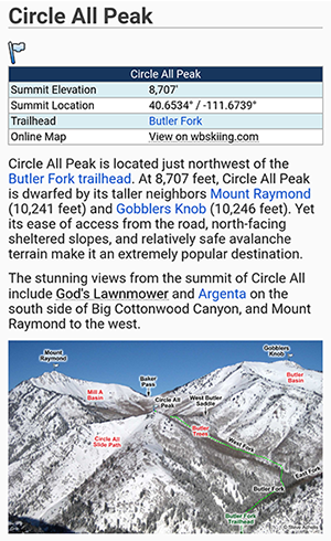
Hundreds of the locations that are displayed in the Wasatch Backcountry Skiing app are linked to the Wasatch Backcountry Skiing Guide. These locations display "links" next to their names in the app. After selecting any of the linked locations and tapping on the "Tap here for more ..." box, information about the location will be displayed in your browser. The information includes details such as skiing difficulty, skinning distance, vertical climb, altitude, aspect, and slope angle. You can tap on the "WBSkiing" text in the top-left corner of Safari to return to the map app.
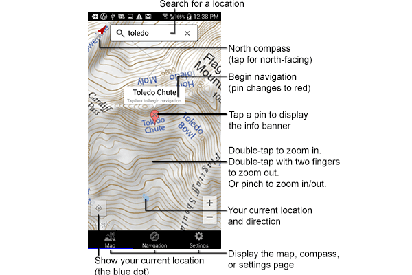
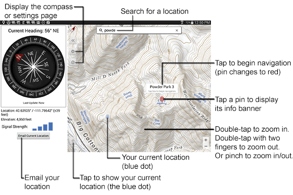
 Zoom in by double-tapping or by pinching; Zoom out with a two-finger double-tap. Move the map by dragging the screen.
Rotate the map with a two-finger twist. A small compass is displayed in the upper-left corner to show the map's orientation. Tap on this compass to return to the north-up orientation.
 Tap on the search field and type a portion of the location name (e.g., "chute"). Then select a name from the list. A red pin will be displayed on the map.

Some locations names are abbreviated and require appropriate search terms. For example, "Mount Olympus" appears in the list as "Mt. Olympus" so it won't appear in the list if you search for "Mount".
Tap on a pin to display its info banner. Tap anywhere in the info banner to begin navigating to that location.

After tapping the info banner, the navigation page will be displayed (you can also display the navigation page by tapping on the Navigation tab at the bottom of the screen). The navigation page displays information about the destination. A blue arrow points toward the destination.

Important: The blue navigation arrow points toward the destination and does not consider avalanche danger, cliffs, rivers, rock fall, or any other hazards. Backcountry travel can be dangerous. It is your responsibility to mitigate hazards.
Important: The compass accuracy can vary by ±10°. Look at your surroundings to avoid "GPS tunnel-vision."
You can cancel navigation by tapping the "X" button on the navigation page or by tapping the info banner.
Your current location is displayed as a blue dot. Tap the current location button in the lower-left corner of the map to center your location (i.e., the blue dot) on the map. If you are outside the map's boundaries, a blue arrow will point toward your current location.

 Tapping the current location button a second time orients the map relative to the earth. A small pointer next to the dot shows the direction your device is pointing. Tapping the current location button a third time, or tapping the small compass, returns to the north-up orientation.
To drop a temporary pin, press and hold on a location. You can then tap on the info banner to begin navigation to the pin's location.
WBSkiing relies on GPS satellite reception to determine your location and to point to destinations. Cell service is not required. The GPS signal strength is displayed at the bottom of the navigation page.
Press the Email Current Location button at the bottom of the Navigation page to send an email containing your current location. You can also send us a location to help us improve the map's database.

The Settings page lets you specify how latitude and longitude, elevations, and distances are displayed.